

What went wrong? Still no answers
One year ago this week, an accident ruptured a pipeline in North Burnaby and sent nearly a quarter of a million litres of crude oil spurting over homes and into Burrard Inlet. Below, in the first part of a special report, reporter Brooke Larsen looks at the impact of the spill a year later.
Brooke Larsen
Burnaby Now
Wednesday, July 23, 2008
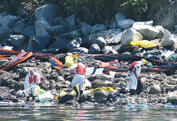
The aftermath: Workers begin the task of cleaning
the shoreline after last summer's oil spill.
CREDIT: File photos/BURNABY NOW
A year after a massive oil spill wreaked havoc on Inlet Drive, investigators aren't saying what went wrong.
Art Nordholm, lead investigator for the Transportation Safety Board, said it will be three or four months before the board releases its findings on the oil pipeline rupture.
Nordholm said the board's investigation focused on the cause of the break, which is also under investigation by the National Energy Board and Environment Canada.
Nearly a quarter of a million litres of oil spurted onto Inlet Drive on July 24, 2007 after a city-hired contractor struck an underground pipeline owned by Kinder Morgan Canada.
The spill caused millions of dollars of damage to homes and city property and launched a large cleanup of Burnaby's shoreline.
Nordholm said a draft report is finished and must be sent out to interested parties for review.
"So it would be a while yet before it's going to be released," Nordholm said, adding he hasn't seen a copy of the report.
National Energy Board spokesperson Sarah Kiley said the National Energy Board's report won't be released until the Transportation Safety Board report is released because the two agencies work together.
Kiley said the energy board is looking at whether there were any violations of the National Energy Board Act, which governs the operation of oil pipelines and carries maximum fines of $1 million.
A spokesperson from Environment Canada declined the NOW's request for an interview.
Headed for the courtroom?
The outcome of the investigations could play a role in the various lawsuits stemming from the spill, city solicitor Bruce Rose said in an interview.
"Potentially, they could be used as evidence," Rose said, adding it's up to the courts to decide who is liable for the spill.
Rose said residents whose homes were damaged have launched "at least a dozen" lawsuits. The suits have not progressed past the initial statements of claim.
"They were filed, but I mean there's been no examinations for discovery," Rose said.
In 2007, Shell Canada filed the first lawsuit stemming from the spill, naming Kinder Morgan Canada, the City of Burnaby and the city's contractor, Cusano Contracting.
Shell wants to recover costs from 11 days of lost production after the spill.
Trans Mountain Pipeline, owned by Kinder Morgan, has also launched a lawsuit, claiming Burnaby failed to locate the company's underground pipeline before it started sewer work on Inlet Drive.
Among the damages in its statement of claim, the company lists loss of reputation, lost oil and the cost of repairing private properties.
The City of Burnaby, meanwhile, maintains that Kinder Morgan supplied the city with inaccurate maps of the pipeline's location.
A pipeline map signed by Kinder Morgan early last year was off by several metres, a City of Burnaby engineer says.
The map, viewed by the Burnaby NOW last week, is part of a crossing agreement prepared by consultant R.F. Binnie and Associates. The city hired R.F. Binnie to prepare the crossing agreement between Burnaby and Terasen Pipelines, operated by Kinder Morgan Canada, for sewer work the city planned to do, Geoff Tsuyuki said,
The agreement, dated Feb. 9, 2007, gave Burnaby permission to carry out sewer work near the company's pipeline.
Tsuyuki, who is manager of contracts and inspections in Burnaby's engineering department, said R.F. Binnie mapped the pipeline's location using information supplied by Kinder Morgan.
"They (R.F. Binnie) have to prepare these drawings based on information they receive from the utilities," Tsuyuki said.
The map was then sent to Kinder Morgan for approval, he said.
The map, which was initialled by two Kinder Morgan employees, bears a stamp that reads, "All information is subject to field verification by a Kinder Morgan inspector."
Tsuyuki said that, while the initials relate to the location of the crossings, it's common for utilities to say at that stage whether they have an "issue" with the maps or the project.
"If they think there's an issue with it, they may say, 'That's too close,'" Tsuyuki said.
He added, "I'm not sure what their (Kinder Morgan's) process is."
Tsuyuki said the map shows the pipeline's location as running a few metres south of where the pipeline rupture occurred.
"According to the map, it's just under three metres," Tsuyuki said.
A spokesperson for Kinder Morgan Canada did not return phone calls before Burnaby NOW deadlines.
© Burnaby Now 2008
Posted by Arthur Caldicott on 24 Jul 2008